|
Monday August 18: Gilgit –
Karimabad
|
Since the centre of Gilgit was
blocked by the chaos caused by the destruction of the major bridge we left by
another out of town bridge over the Hunza river.
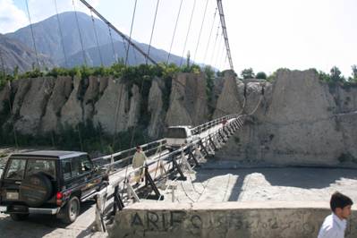
Now, this bridge was seriously interesting. It was (as normal) a one-way suspension
bridge strung high above the river, which here flowed through yet another
gorge, this time cut into the river gravels. The gorge dictates that the road
must make a sharp right angle turn at both ends of the bridge. At the far end
this right angle turn takes the road directly into a dark one-way tunnel for
about 100meters and you can see that something as large as a minibus would
just about squeeze through; a lorry would have no chance. Thus, there is no
way that the traffic coming south can know whether there is a vehicle coming
the other way. In theory there are men at both ends of the one-way section
that regulate things, but this is Pakistan! Sure enough, when we
got there there was a large queue as two vehicles
had met in the middle of the bridge and neither was about to give way. We
watched this for about 15 minutes and then sent Ehsan to sort things out. Now
I’m not in fact certain that Ehsan did actually make the difference, but
almost immediately he got there the problem was resolved, and I can believe
that he did make a difference as, when he wants to, he can certainly exude
authority. This bridge certainly did move about as we crossed it.
|
|
|
Soon after emerging from the tunnel we were on the
northern, and most famous, section of the KKH.
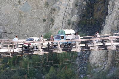
At this point it is
apposite to say a few words about the Karakoram Highway. The very word
‘Highway’ conjures up at least a two-lane surfaced road. Wrong. For the most
part the highway is single track with just about enough room to pass, and
whilst it was originally metalled (i.e. when built), nowadays not much more
than 60% outside of towns and villages has a metalled surface; nature has
taken its toll.
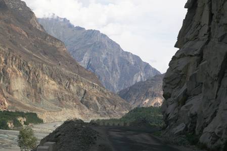
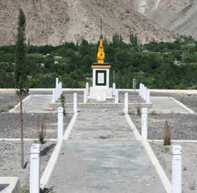
The KKH was built by the China and Pakistan from 1968 - 1978. The
Chinese built almost all the bridges and much of the road, and incurred most
of the casualties and there is a memorial to all those that lost their lives
(see photograph below). It is one of the world’s major feats of
engineering because of the terrain it cuts through, the nature of the rocks
and the altitude. The terrain means that the road is mostly cut through deep
gorges themselves cut by the Indus and Hunza rivers with only a few wider flatter areas. The
mountains are incredibly unstable. Not only is the rock itself largely micaceous and thus very prone to crumbling and slipping,
but this is a major earthquake zone; it does not need a big earthquake to
start rocks falling, any one of the dozens of small tremors each week is
sufficient. Then, there is the rain which comes in torrential storms causing
flash floods and landslides. Water is incredibly destructive, even a stream
constantly flowing over the road gradually strips off the surface and erodes
the base underneath. And finally, there is the altitude; about
2,100meters at Gilgit rising to 4,900meters at the
top of the Khunjerab pass; not only does this make
physical activity difficult, but the winter freeze/thaw cycles further loosen
the rock. Thus it was not just a major feat to actually build the road, but
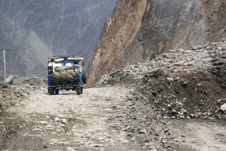
it is also a major feat simply to keep it open. For example, the day of the
rain which we experienced in Gilgit caused a major landslide at the Rakaposhi Viewpoint which had covered about 80meters of
road with a mud and rubble landslide. Vehicles like ours were able to pick
their way over this landslide, but landslides are often simply too big even
for jeeps. Landslides do not just cover the road; they often wipe-out whole
sections, so that a new piece of road must be cut. It is clear that without a
major on-going effort, the mountains would largely reclaim the road in about
five years. It is also clear that the road is a major economic link both into
China
and for the whole of the Hunza valley and
represents an important psychological and actual commitment to the Hunza.
|
|
|
As you go around Pakistan you see all sorts of
trades being practiced. By the side of the road was the enterprise of a man
famous in the region for his wood-turning – bowls and rice servers being a
speciality – and he used water power from a stream to turn his lathe. Apricot
wood is his speciality, and we all bought something of course.
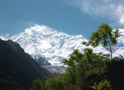
We
stopped for lunch – we were still eating biryanis
and vegetables and rice at this stage – at a café and shop called Rakaposhi Viewpoint. You get an absolutely fabulous view
of the snow-covered slopes of Rakaposhi which rises a further 5,300metres above to a total height
of 7788meters. The view is truly spectacular,
though there was some cloud that day, and the photograph shown is actually
from our return trip down the valley after visiting China. Across
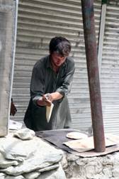
the road from the café was a chap with a stall, and all he did all day was
make chapattis, principally but not exclusively for the cafe – and very good
they were too. The rains of the previous day had not only created the
landslide referred to earlier and which was only about 100yds from the café,
but had also washed away a large chunk of the café’s garden.
The Hunza valley, particularly
where the valley broadens out, is very beautiful. Irrigation and climate
enable many fruits to be grown – cherries, peaches, apricots, apples, pears
and grapes – which are ‘exported to the rest of Pakistan. As a result, these
are some of the more prosperous farmers in Pakistan.
|
|
The use of the word
‘exported’, albeit in parenthesis is quite appropriate. The Northern Areas although formally a part of Pakistan is less integrated into Pakistan than say the Sind or the Punjab. Thus, the people do not have a vote for members
of parliament, but on the other hand they do not pay federal taxes either.
Their status however, should in no way be compared to that of the ‘Tribal
Areas’ which are much more lawless and viewed as distinctly inferior to the
Northern Areas. Ehsan represented the (apparently) general view of the people
of the area that the departure of Musharraf was a
loss as he had had an affinity with the Northern Areas where he had spent
much of his army career.
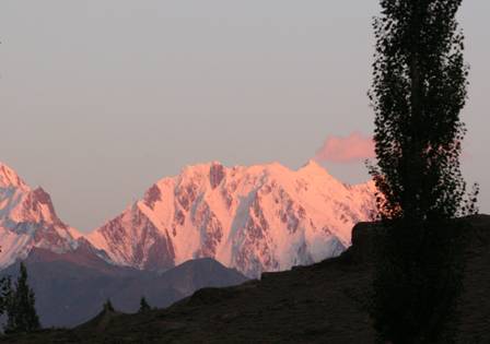
As
well as the fruit trees, the other tree or northern Pakistan (and of ‘Asian’ China) is the
Poplar. These tall slender trees sway gracefully in the wind, often
highlighted against the snow-capped mountains. In the evening the clouds
cleared and there were some fantastic views of the sun setting on Rakaposhi.
|